

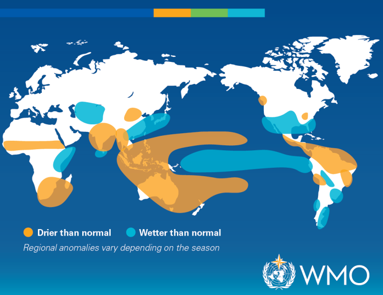
El Niño is a climate pattern that begins in the tropical Pacific Ocean. It happens when sea surface temperatures in the central and eastern Pacific become warmer than usual, changing how heat and moisture move through the atmosphere. That shift can affect weather far beyond the Pacific.
In 2026, scientists are watching El Niño closely. The World Meteorological Organization (WMO) warned that conditions were developing, with an 80% likelihood during June-August 2026 and probabilities near or above 90% of continuing until at least November. Most forecast models suggest the event will be at least moderate, with a chance of rapidly becoming strong.
El Niño Isn’t the Same as Climate Change
El Niño is natural. It usually develops every 2 to 7 years and often lasts around 9 to 12 months. It’s part of the El Niño–Southern Oscillation, or ENSO.
Climate change doesn’t “cause” El Niño, but today’s El Niño events happen in a warmer world, and that matters. Warmer air and oceans can add more heat and moisture to the climate system.
WMO also notes that there’s no evidence that climate change increases the frequency or intensity of El Niño events, but it can amplify some associated impacts, especially extreme heat and heavy rainfall.
Which Regions May Be Wetter, Drier, or Hotter?
El Niño doesn’t affect the whole world in the same way.
According to the WMO, El Niño is typically associated with increased rainfall in parts of southern South America, the southern United States, the Horn of Africa, and central Asia.
It’s often linked with drier conditions over Central America, northern South America, the Caribbean, Australia, Indonesia, and parts of southern Asia.
For temperature, the picture is broader. WMO’s 2026 update forecast above-average temperatures nearly everywhere for June-August 2026. That doesn’t mean every place will experience dangerous heat or heatwaves; just that many regions may be warmer than usual for their season.
These patterns aren’t guarantees. Each El Niño is different, and impacts depend on intensity, timing, duration, season, local geography, and interaction with other climate patterns.
What Should People Pay Attention To?
If your area is expected to be hotter or drier, follow heat alerts, wildfire warnings, water-use guidance, reservoir updates, local news, and electricity-demand warnings.
If your area is expected to be wetter than usual, follow flood alerts, landslide warnings, road closures, transport delays, drainage problems, and warnings for low-lying areas.
The best sources to check will be your national meteorological service, local emergency agencies, water authorities, trusted outlets, and official health alerts.
Turning Forecasts Into Preparation
El Niño’s value is that it gives people, communities, and governments time to prepare before weather risks become serious problems.
Governments and institutions carry the biggest responsibility: strengthening infrastructure, managing risks, protecting vulnerable communities, supporting farmers, preparing health systems, and communicating clear, timely warnings.
For regular people, the role is different but still important: know your local risks, follow trusted updates, and act early when warnings are issued!
References & Resources
- U.S. Geological Survey. (2016, March 1). What is “El Niño” and what are its effects?https://www.usgs.gov/faqs/what-el-nino-and-what-are-its-effects
- WMO. (n.d.). El Niño / La Niña. https://wmo.int/es/topics/el-nino-la-nina
- WMO. (2026a, June 1). Prepare for El Niño. World Meteorological Organization. https://wmo.int/news/media-centre/wmo-prepare-el-nino
- WMO. (2026b, July 1). El Niño is forecast to intensify, increasing likelihood of extreme weather. World Meteorological Organization. https://wmo.int/news/media-centre/el-nino-forecast-intensify-increasing-likelihood-of-extreme-weather


Leave a Reply